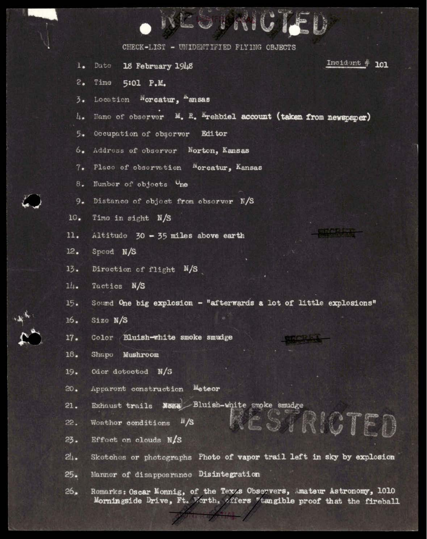
Page 3 records the entry as a "CHECK-LIST - UNIDENTIFIED FLYING OBJECTS" item for Incident #101. The visible fields identify a single object, location "Norcatur, Kansas," observer source "M. R. Krehbiel account (taken from newspaper)," and altitude "30 - 35 miles above...
UAPs.world keeps this analysis report connected to its original source path, release context, and related analysis path so readers can inspect the evidence trail directly.
Analysis report summary
This analysis page exposes the report substance directly for readers and crawlers, while the research viewer remains the place for source inspection, frame review, and follow-up work.
Observation
Page 3 records the entry as a "CHECK-LIST - UNIDENTIFIED FLYING OBJECTS" item for Incident #101. The visible fields identify a single object, location "Norcatur, Kansas," observer source "M. R. Krehbiel account (taken from newspaper)," and altitude "30 - 35 miles above earth." The same page also records "apparent construction" as "Meteor," "manner of disappearance" as "Disintegration," and a photograph described as a vapor trail left in the sky by an explosion. Page 4 supplies the control context. The remarks state that the February 18 fireball over northern Kansas was "just that" because meteorites had been recovered from it. The page describes smaller recovered fragments, a later approximately 109-pound...
Hypothesis To Test
The capture lead asks whether the archive supports the "30-35 miles above earth" claim. It does, but only as an incident checklist field for a fireball/meteor event. The source supports documenting the altitude estimate; it does not support converting the estimate into evidence of a controlled craft, propulsion system, or non-human vehicle.
Why It Matters
The "30-35 miles" line is real and citable. The important analytical move is to preserve its status: it is a source-visible altitude estimate inside an incident checklist that immediately points toward a meteor explanation and later recovered meteorite material. In other words, this is a good archive literacy example. A dramatic altitude value can be genuine while the event still resolves toward a conventional astronomical object.
Working Assessment
Disclosure-forward neutrality gate: passed. The analysis starts from the captured page and the user's question, keeps the outlandish reading testable but does not upgrade it into proof, and presents the ordinary/control lane alongside the archive-significance lane. The strongest source-backed finding is that Incident #101 documents a 30-35 mile altitude estimate for the February 18, 1948 Norcatur/Norton fireball. The strongest limiting finding is that the same record identifies the apparent construction as meteor, describes disintegration, cites recovered meteorites, and names an achondrite recovery. Evidence that would reopen the exotic lane would need to show that the recovered material, trajectory, or...
Classify this source for 2 points, mark useful or misleading records for 1 point, or submit observations for curator review. Public contribution points progress through Observer, Analyst I, Analyst II, Case Builder, and Archivist and can unlock field desk themes.