C144 Cajamarca Theodolite Readings and the Venus Comparison
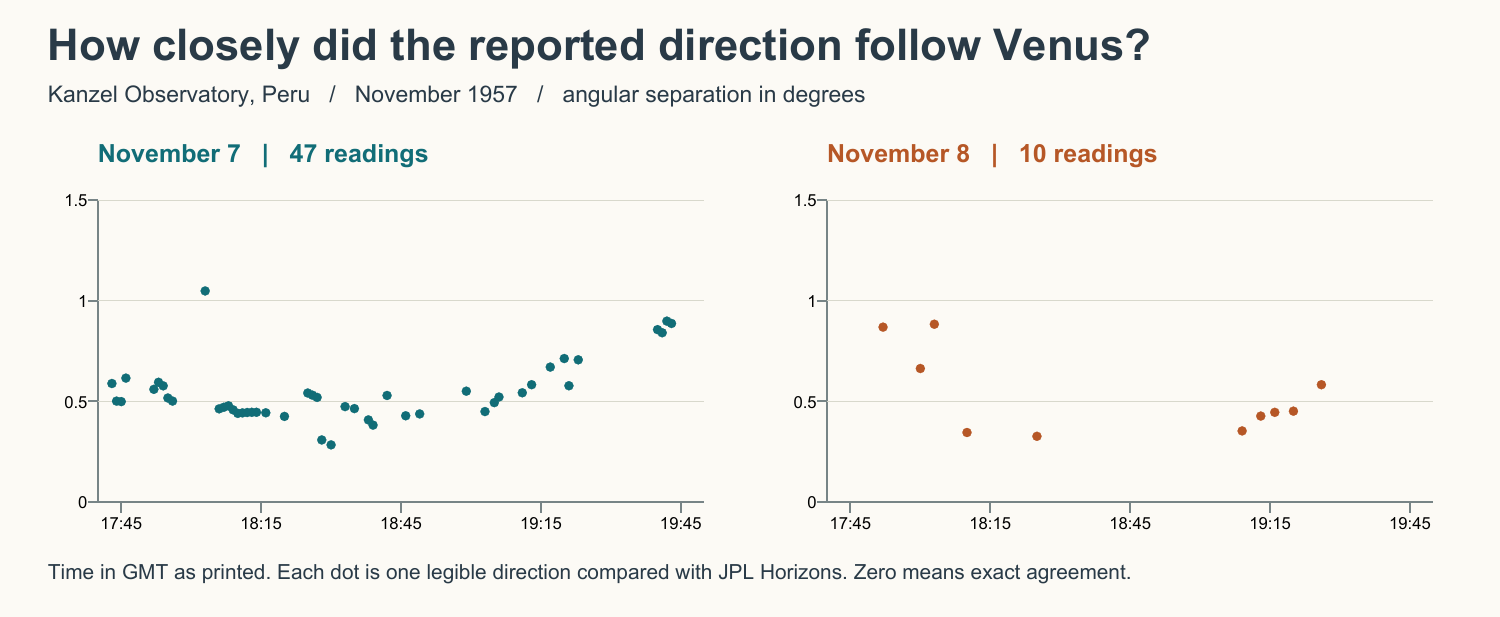
The November 7 table begins at 17:43 GMT with azimuth 123.2° and elevation 48.6°. At 19:43 the readings are 156.8° and 69.3°. Venus moved through nearly the same part of the sky. At 18:10 on both days, the printed readings are identical at 127.0° and 54.2°. The corresponding...
UAPs.world keeps this analysis report connected to its original source path, release context, and related analysis path so readers can inspect the evidence trail directly.
Analysis report summary
This analysis page exposes the report substance directly for readers and crawlers, while the research viewer remains the place for source inspection, frame review, and follow-up work.
Source Basis
The field report locates the observatory at 7°25′30″ S, 78°20′30″ W, 3,750 metres above sea level. The observer described a leveled Zeiss recording theodolite on a fixed concrete base. Another observer telephoned an approximate position on November 7. Only the observatory supplies a series of azimuth and elevation measurements. The call helps explain how the light was acquired, but supplies no second measured line of sight for estimating range. Station and acquisition · Instrument mounting.
Observation
The November 7 table begins at 17:43 GMT with azimuth 123.2° and elevation 48.6°. At 19:43 the readings are 156.8° and 69.3°. Venus moved through nearly the same part of the sky. At 18:10 on both days, the printed readings are identical at 127.0° and 54.2°. The corresponding Venus positions are 126.76°/54.62° on November 7 and 126.61°/54.46° on November 8. The repetition covers a moving direction and is more informative than an isolated match. Repeated rows from the same instrument share clock and alignment errors. They should not be treated as 57 independent confirmations. Opening readings · Later and next-day readings.
Observation
Date
Usable rows
Median angular separation
Smallest to largest
November 7
47
0.50°
0.28°–1.05°
November 8
10
0.45°
0.33°–0.88°
Calculation. Use JPL Horizons observer tables for Venus at the printed station coordinates, with east-positive longitude −78.341667°, latitude −7.425°, height 3.75 km and airless apparent azimuth/elevation. Pair each printed GMT minute with the calculated direction for that minute. The separation is the angle between the two unit sight lines. Equivalently, its cosine is sin(e₁)sin(e₂) + cos(e₁)cos(e₂)cos(a₁−a₂), where e is elevation and a is azimuth. No fitted clock or pointing correction was applied. The last November 7 row at 19:47 gives azimuth 159.0°, but the final elevation digit is indistinct. It is the only November row excluded. November 7 ephemeris · November 8 ephemeris · JPL observer-table...
Working Assessment
The November series supports a planetary explanation more strongly than the original catalog summary alone suggests. The residual differences show why this remains a candidate identification. The file gives no pointing calibration against a known star for those sessions, clock error estimate or simultaneous measured bearing from another station. A calibrated reduction of the original recorder disk could test for a systematic offset. A synchronized second station showing appreciable parallax would weaken the Venus explanation. Neither range nor vehicle speed can be recovered from these single-station angles alone. An earlier Air Force file documents a practical comparison. At Godman AFB in Kentucky,...
November readings
The two direction columns give azimuth/elevation in degrees. Predicted angles and separations are rounded here. Use the linked observer tables for greater precision.
Classify this source for 2 points, mark useful or misleading records for 1 point, or submit observations for curator review. Public contribution points progress through Observer, Analyst I, Analyst II, Case Builder, and Archivist and can unlock field desk themes.